Hivemapper is building one of the first on-chain, decentralized global maps powered completely by the people. Since launch in November 2022, the Hivemapper network has significantly grown its active contributor base and map coverage.
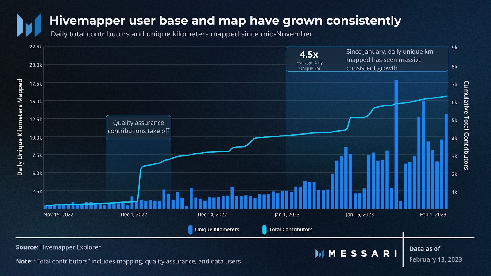
Over 301,000 unique kilometers have been added to the network’s decentralized map in the past 3 months. Most of the map is congested around major metropolitan areas such as Los Angeles and Seoul. Additionally, the daily average of unique mapping contribution has increased by 4.5x since January, largely due to the steadily rising number of network contributors.
The total unique user base has grown by 30x since November to nearly 6,300 users. This metric comprises 30% mapping contributors, 69% quality assurance (QA) contributors, and <1% data users. Mapping contributors are particularly important because they actively trace roadways with a Hivemapper dashcam. The growth of this user segment is directly correlated with the Hivemapper team’s dashcam production, which has been increasingly catching up to their evergrowing waitlist.
QA contributors verify contributions from dashcam footage. Both the mapping and QA contributors receive the platform’s native HONEY token in exchange for their contributions. The combined efforts of these contributors will ideally create a comprehensive, high-quality, and up-to-date map of the world.
Finally, data users query the network’s API for external usage. Enterprises and developers can purchase map credits — fixed at $0.02 USD — that can be used to query map data. As users consume map imagery, a corresponding amount of the HONEY token is burned. Then, an equivalent number of HONEY tokens is added back to complete Hivemapper’s net emission model.
Current Usage
Currently less than 1% of the world’s roadways have made their way onto Hivemapper’s network. As such, it’s not terribly surprising that there is very little usage of Hivemapper’s map data since launch. The network needs to expand its mapped territory before it can incentivize external application development. So how long will it take before the Hivemapper team has a usable dataset?
Let’s look at Los Angeles, one of the most active cities in terms of mapping contributors. According to the global contribution metrics over the past two months, each mapper contributes an average of 10 unique kilometers per day. The city currently boasts 120 mappers, with about 15% of the 134,000 total kilometers mapped.
Assuming no new contributors are added and that contributors prioritize mapping previously untouched areas, LA will have a functioning map in approximately 3 months. Granted, this timeline is a rough estimate that ignores several key details involved in how map footage is sourced, vetted, and approved. However, if the same logic can be applied to other active urban areas, then developers could potentially start building on Hivemapper’s network within the year.
Mapping Economy
Billions of people around the world depend on maps each day. Maps are used by insurance providers, real estate services, logistics companies, navigation and delivery apps, and governmental organizations, just to name a few. Maps are an essential part of the world’s technology infrastructure and represent a $300B market.1
The Problem
Today, global maps are largely controlled by a few companies because they are extremely expensive to build. This has led to numerous problems with today’s maps:
High costs for businesses: The cost of mapping APIs continues to increase due to the lack of competition.2
Uneven freshness and coverage: These maps are not as fresh as they should be due to the incredible expense required to build and maintain them. Developing markets have vastly inferior maps given that the high cost to map breaks the economic models.
Free use of user data: Existing maps use our private and sensitive location data to improve their own maps without compensation.
Prone to censorship: Big tech companies operate a wide set of businesses in many countries, and are often forced to censor or modify their maps to satisfy politicians and land owners.
The Benefits of Building a Mapping Network on the Blockchain
Blockchain and crypto incentives solve these problems by dramatically reducing the cost to map on a global scale, while rewarding contributions to the map and promoting freshness and uncensored quality.
High quality 4K dashcams are widely available for only hundreds of dollars and can be connected to software for efficient collection of 4K street-level imagery. Map QA reviewers, annotators, and annotation QA reviewers are incentivized with ownership to maintain the quality of the map. Additionally, thanks to the decreasing cost of machine vision compute cycles it is now feasible to transform imagery to valuable map data on a global scale.
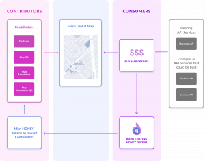
Imagine a network of map contributors and map consumers intricately connected on a blockchain, participating in the exchange of valuable map data. Map contributors build and refresh the map by capturing 4K street-level imagery, carrying out quality assurance, and annotating imagery. Map consumers leverage the map via a set of APIs such as images, direction, geocoder, and more.
Hivemapper’s decentralized global map and cryptocurrency
The Hivemapper Network is a system that incentivizes map coverage, freshness, and quality with ownership. By installing a simple 4K dashcam on a car or truck, a contributor can earn a new cryptocurrency, own part of the decentralized global map, and support the world’s critical geospatial infrastructure in a cost-effective way.
Powering the Hivemapper Network is the decentralized global map on the blockchain and its cryptocurrency HONEY . With the introduction of a decentralized mapping network and cryptocurrency, the mapping network injects decentralization and built-in crypto incentives into an industry currently controlled by monopolies and governments that take our data for free. The result is a state-of-the-art map of our world that is constantly-renewing, high quality, truly covers our whole world, and is collectively owned by its contributors.
Fig. 1 / The Hivemapper Network – This diagram shows the two-sided marketplace between map contributors and map consumers interacting on the Hivemapper Network with its cryptocurrency token HONEY.
System Overview
Map Tiles
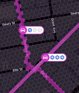
The global map is divided into small hex shaped tiles referred to as map tiles. The map tiles are the atomic unit of the map and based on H3 cells. We intentionally use small H3 cells as the basis for our map tiles (shown in the graphic below) to make it easy to start contributing and to avoid issues with “partial” tiles contributed.
Fig. 2 / Map Tiles – Map tiles are the atomic unit of the Hivemapper map that contributors use to build and refresh coverage. Each map tile is hex shaped. Trillions of these hex shaped tiles cover the entire earth.
4K Street-Level Imagery to Map Tiles
The 4K street-level imagery and related GPS metadata collected with approved dashcams and the Hivemapper app serve as the raw ingredients for the global map. This data provides coverage for map tiles as seen in Figure 3 below.
Fig. 3 / Map Tiles Along a Path – Map tiles that have been covered on the road are represented in pink, as shown by H3 cells.
Map Contributors
The collective work of map contributors on the Hivemapper Network results in a high quality global map. The chart below details the different types of map contributors and the type of work they do on the mapping network.
Contributor
Work They Do
Drivers
Collect 4K street-level imagery via a supported 4K dashcam and Hivemapper app
Imagery QA Reviewers
Validate the 4K street-level imagery collected by drivers
Annotators
Annotate the map with details such as street direction and name. Annotations can be broadly defined; for example, a customer may pay to add artwork associated to the map
Annotation QA Reviewers
Validate the work of Map Annotators
Software Developers
Extend the protocol, product, and work on core mapping features and the Hivemapper app
The Hivemapper Dashcam
Fig. 4 / Hivemapper Dashcam – The Hivemapper Dashcam is an open source camera based on the Open Dashcam specifications that is optimized for collecting imagery from a vehicle for the purpose of mapping.
In the summer of 2022, Hivemapper will begin selling the world’s first crypto-enabled dashcam. The Hivemapper Dashcam is an open source dashcam that natively integrates with the Hivemapper Mapping Network through a seamless mobile app.
The Hivemapper Dashcam is based on the Open Dashcam specifications that ensures:
Location Authentication: Multiple layers of security to ensure that the dashcam is authentically geolocating its position
Automatic data transfers: Automatically transfers the collected data from the dashcam to the Hivemapper Network via integration with the Hivemapper Contributor App for iPhone and Android
Dynamic data collection: Dynamically determines the data required for the map – ignores the rest
These capabilities make it the ideal dashcam for mapping on a decentralized network.
Hardware manufacturers can incorporate the Open Dashcam specifications in their own dashcams, and seek approval from the Hivemapper Foundation to run their compliant dashcams on the mapping network.
Honey Token
HONEY is the Hivemapper cryptocurrency of the decentralized mapping network. The Hivemapper Network is built on top of the Solana blockchain.
Map contributors mine HONEY by contributing to the Hivemapper Network. A fixed number of HONEY tokens are minted decreasingly over time. The maximum number of HONEY tokens that will ever exist is 10 billion.
Map API Services
APIs built on top of the global map enable developers to cost effectively integrate maps and geolocation services into their applications. Today, Hivemapper Inc. offers individuals and organizations the powerful Map Image API. The set of APIs that Hivemapper Inc. and other organizations can build and commercialize on top of the global map includes Driving Directions, Geo Search, Traffic, and more.
The Hivemapper Foundation ensures that any company or organization can build and commercialize API services on top of the global map.
Map Consumers
Customers who want to integrate Hivemapper’s map APIs into their applications can purchase API calls with Map Credits. Map Credits are created by burning HONEY tokens, ahead of any use of map APIs. These burned tokens then increase the number of tokens available to mint and to pay to map contributors.
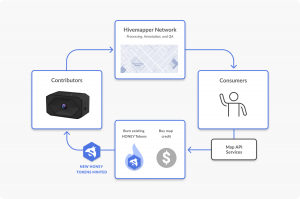
The Burn and Mint Equilibrium
The Burn and Mint Equilibrium with Net Emissions model is used, such that whenever map consumers burn tokens to access the network, an equivalent number of tokens is added back into the rewards pool for map contributors as shown in Figure 5 below.
Fig. 5 / The Burn and Mint Equilibrium – When map consumers use map APIs this transaction burns tokens, and an equivalent number of tokens is added back into the pool to reward contributors.
At a high level, contributors, including drivers, annotators, and QA reviewers, build the database of fresh and accurate map data in exchange for HONEY. Consumers of the data pay into the network by purchasing and burning tokens to compensate the contributors for their work.
Future Areas
Today, the mapping network focuses on street level maps. Next, the network will introduce map annotations enabling map editors to edit the map alongside the machine learning algorithms to add new layers of data to the map.
Yet, this is just the beginning. Global data collection for a global map, incentivized by the HONEY cryptocurrency token and protocol, is the right approach to building a global map. With this in mind, there are multiple technologies that hardware and software developers can use to add additional layers to the global map in order to meet the needs of customers:
Additional imagery sensors such as 360 cameras from street level
Support for collecting imagery from scooters and bikes to support high quality maps for alternative transportation modalities
Use of air quality sensors to incorporate air quality data into the map
Use of lower cost RGB-D, radar, and LiDAR sensors to build 3D maps and street level object mapping
Airborne data collection via drones to provide the high precision aerial perspective
Use of satellite imagery for a broad scale aerial perspective
Disclaimer
This content by cryptomentor.info is in no way a solicitation or offer to sell cryptocurrencies, securities, shares, financial assets or investment advisory services. cryptomentor.info is not intended to be a source for professional advice. Our content is intended to be used and must be used for informational purposes only and this is not a place for giving or receiving financial advice, advice concerning investment decisions or tax or legal advice. It is very important to do your analysis before making any investment based on your circumstances. Readers should always seek the advice of a qualified professional before making any investment decisions.